Where the Wind Remembers the Road: A Travelers Guide to Ladakhs High Passes
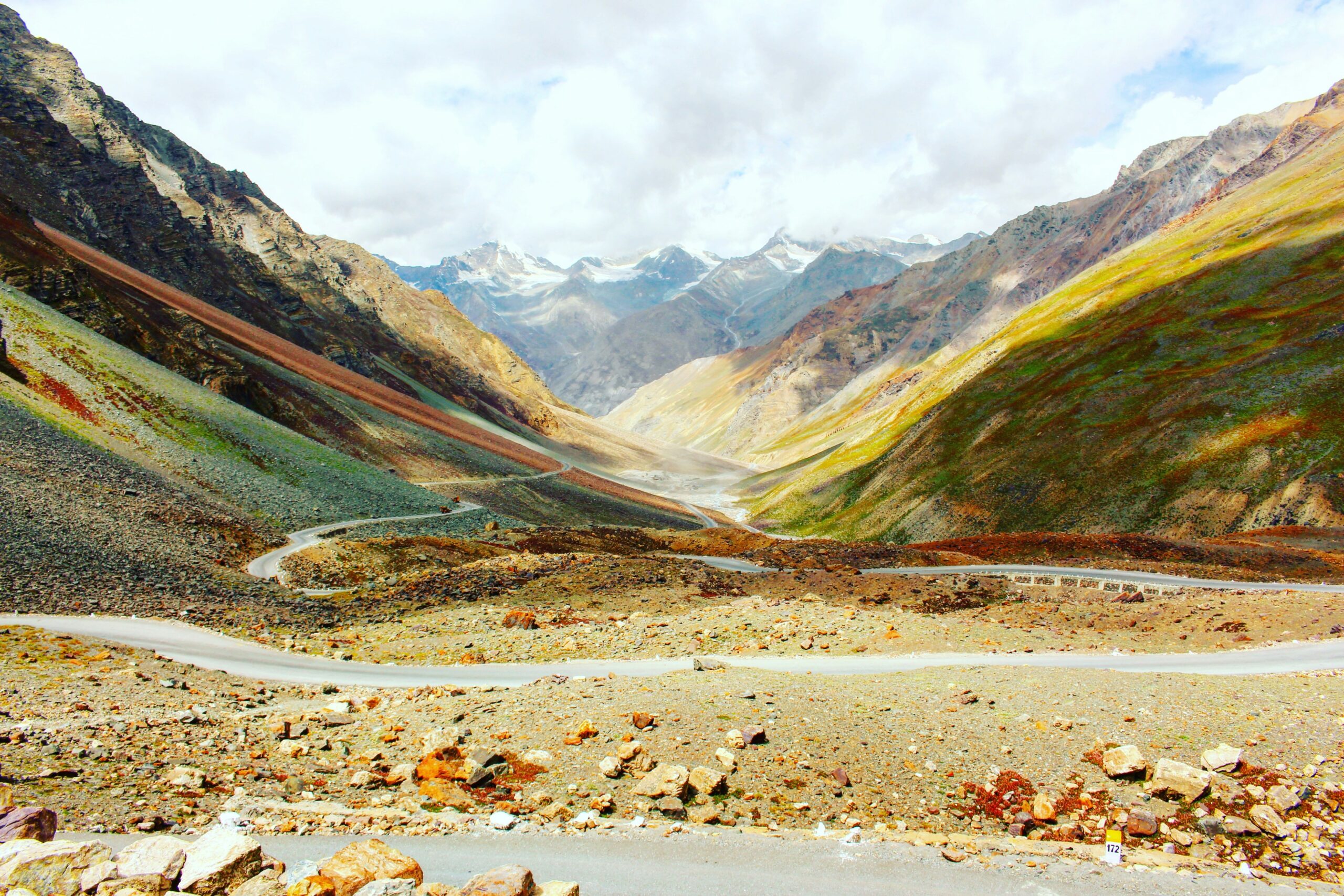
How High Passes Teach Us to Travel Differently in Ladakh By Declan P. O’Connor Opening Reflection: Where Roads Rise Into Memory Why High Altitude Roads Shape the Traveler Before the Destination Does Every journey into Ladakh begins, at least in our imagination, with a destination. A lake whose blue looks unreal on a phone screen. A monastery stitched to a cliff. A valley whose name sounds almost mythical from far away in Europe. Yet the more time you spend in this corner of the Himalaya, the more you understand that it is not the destination that forms you, but the roads that rise toward it. The high passes of Ladakh – the long climbs to Zoji La and Fotu La, the steep switchbacks of Khardung La, the remote ramparts of Umling La and Marsimik La – have a way of slowing a traveler down long before the engine runs out of torque. They ask you to breathe differently, to think differently, and to admit that you are an animal that depends on oxygen more than pride. At sea level, a road is simply infrastructure. It is a story of convenience and speed, an encouragement to fit more into the day. At altitude, however, a road becomes a kind of moral landscape. The higher you go, the less your plans matter and the more your body does. The air thins, the margins narrow, and the usual European instinct to compress experience into a long weekend begins to look faintly ridiculous. Here, the journey to Ladakh’s high passes is not a warm-up for adventure; it is the adventure. And if you listen closely – to the engine straining, to the silence between gusts of wind – you begin to suspect that the road is remembering something about you that you have forgotten about yourself. Somewhere above 4,000 meters, your itinerary stops being a schedule and starts becoming a confession: this is how much hurry you brought with you, and this is how much you are willing to let go. Understanding Ladakh’s High Passes The Old Logic Behind a Pass Long before there were asphalt ribbons across the Himalaya, there were passes. They were not, in the beginning, scenic viewpoints or opportunities to post photographs from “the roof of the world.” They were survival routes – the narrow seams in a landscape that otherwise refused to be crossed. In Ladakh, a high pass is the place where geography finally negotiates with human desire and says, grudgingly, “All right, you may pass here – but slowly, and only at a cost.” Sheep caravans, salt traders, pilgrims on foot: for centuries, they threaded their way over saddles like Pensi La toward Zanskar, or along the rough tracks that prefigured today’s Srinagar–Leh and Manali–Leh highways, trusting not in GPS, but in memory and rumor. You can still feel that older logic on Ladakh’s high passes. Even when the road is well graded and the tarmac new, there is a sense that you are following someone else’s patient discovery, not imposing a modern line on a blank map. Names like Baralacha La, Namika La, or Taglang La carry the weight of this history. They are not simply coordinates; they are the record of where feet, hooves, and later wheels found just enough ease in the terrain to slip between ranges. To drive here is to inherit that work, often without realizing it, and to discover that the word “shortcut” disappears somewhere above 3,500 meters. Why Motorable Passes Matter Today In the era of satellite maps and flight comparison websites, it is easy to think that roads no longer matter, only arrival does. Ladakh politely disagrees. The network of motorable passes – the Srinagar–Leh road over Zoji La and Fotu La, the Manali–Leh highway across Baralacha La, Nakee La, Lachulung La, and Taglang La, the spurs to Nubra via Khardung La and Wari La, the tracks that climb to Chang La, Marsimik La, and Photi La – has reshaped daily life in ways both obvious and subtle. Medical care can arrive faster; students can leave villages for higher studies; vegetables reach markets before they freeze. Yet the passes have not been tamed. They remain seasonal, temperamental, bound to snow and wind. For travelers, motorable passes in Ladakh are less about bragging rights and more about access to a living culture at altitude. They make it possible for a European visitor to wake in a guesthouse in Leh and, within a day, drink tea in a Nubra village or stand above Pangong Lake. But they also insist on certain disciplines: acclimatization days, flexible itineraries, and a willingness to turn back when the weather – or the Border Roads Organisation – declares the day finished. In this way, Ladakh’s high passes teach modern travelers that infrastructure is not omnipotent and that roads, even when paved, do not cancel the mountain’s authority. Safety & Rhythm of Altitude Travel One of the quiet truths that Ladakh’s high passes whisper, if you allow yourself to hear it, is that the human body does not negotiate well with speed. Climbing from Delhi’s low, thick air to Khardung La in less than forty-eight hours is not an achievement; it is a biological provocation. The same is true for the long, beautiful drive from Manali over Rohtang, Baralacha La, Nakee La, Lachulung La, and Taglang La toward Leh. The scenery invites haste; the body demands increments. Acute mountain sickness is not a character flaw, but it is almost always a consequence of ignoring rhythm. Practical wisdom here is simple, but uncompromising: spend nights in Leh or Kargil before climbing higher, let Zoji La or Fotu La be your first encounter with thinner air, not your last. Treat the high passes as exams you sit only after attending the classes of acclimatization. And remember that Ladakh’s road crews close passes for reasons that have nothing to do with inconvenience and everything to do with survival. The traveler who listens – who accepts that “no” from the mountain is sometimes the most generous word – discovers a different kind of freedom. The journey ceases to be an assault on peaks and becomes, instead, a conversation with them. The Northern Gates: Passes Connecting Leh & Nubra Valley Khardung La: The Mythic Threshold to Nubra Khardung La is, for many visitors, the first name they hear when they start dreaming about Ladakh’s high passes. For years it was advertised, inaccurately but insistently, as the highest motorable pass in the world. The claim has since been revised by cartographers and overtaken by new roads, but the legend persists. Standing at roughly 5,359 meters above sea level, Khardung La does not need the superlative. It occupies a more important role: it is the hinge that swings a traveler out of the Indus Valley and into the wide, braided landscapes of Nubra. The road from Leh climbs steadily, past monasteries and army posts, into a world where sound thins out and color changes register more vividly. Prayer flags erupt along the ridgeline, trucks labor upward in low gear, and every hairpin feels like a small decision about how much discomfort you are willing to endure for the view. From the top, the panorama is not tidy; it is sprawling, broken, and deeply moving. The traveler looks down on the road that brought them there and realizes that this single pass has reoriented their entire mental map: Leh is no longer a destination, but a base camp; the real journey unfolds on the other side, in Nubra’s sand dunes, apricot orchards, and cold rivers. Wari La: The Quiet Rival to Khardung La If Khardung La is the extrovert of Ladakh’s high passes – crowded, photographed, lined with signboards – Wari La is its introverted cousin. Slightly lower in altitude, but steeper and far less frequented, Wari La provides an alternative route between the Leh–Pangong side and Nubra Valley. It connects Sakti and the Pangong approach road to the Agham side of Nubra in a long, looping arc that most rental agencies will not encourage you to attempt without good reason and better preparation. It is precisely this reluctance that makes the pass alluring for those who feel that travel has become too curated, too choreographed. On Wari La, the sense of exposure is more intimate. There are fewer vehicles, fewer signboards, and often no mobile signal. The peaks feel closer, the sky heavier, the silence deeper. You are not just visiting Ladakh’s high passes; you are briefly sharing the road with shepherds, local drivers, and the wind itself. For a European traveler used to highways and rest areas, this can be unsettling and liberating in equal measure. The geography demands focus, the altitude demands humility, and the reward is a kind of solitude that is increasingly rare on our planet: not manufactured, not packaged, simply the by-product of being on a road that most people still consider a little too inconvenient to bother with. The Eastern Highways: Roads Toward Pangong & Changthang Chang La: The Icy Stairway to Pangong East of Leh, the road to Pangong Lake climbs toward Chang La, a pass whose name is rarely spoken without a small, involuntary shiver. Chang La is not the highest pass in Ladakh, but it feels particularly abrupt. Its steep ramps, frequent ice, and sudden weather make it less of a postcard stop and more of a stern introduction to the Changthang plateau. At roughly 5,360 meters, this is a place where moisture crystallizes into small, insistent inconveniences: frozen patches in the shadows, wind that seems to reach inside your jacket, the mild headache that reminds you that your red blood cells have not yet caught up with your plans. Yet it is also where the anticipation of Pangong begins in earnest. Around each bend, you catch hints of the world you are about to enter: a wider sky, a paler horizon, a sense that the familiar categories of valley, village, and town are about to give way to something sparser. The road over Chang La is patrolled by the usual Ladakhi mixture of practicality and humor – tea stalls, army boards, prayer flags. But beneath the signage and the selfies, there is a deeper story: humanity insisting on a fragile corridor throu
source https://lifeontheplanetladakh.com/blog/ladakh-high-passes-travel-guide/


Comments
Post a Comment