Lower Indus Brokpa Corridor Ladakh villages travel guide
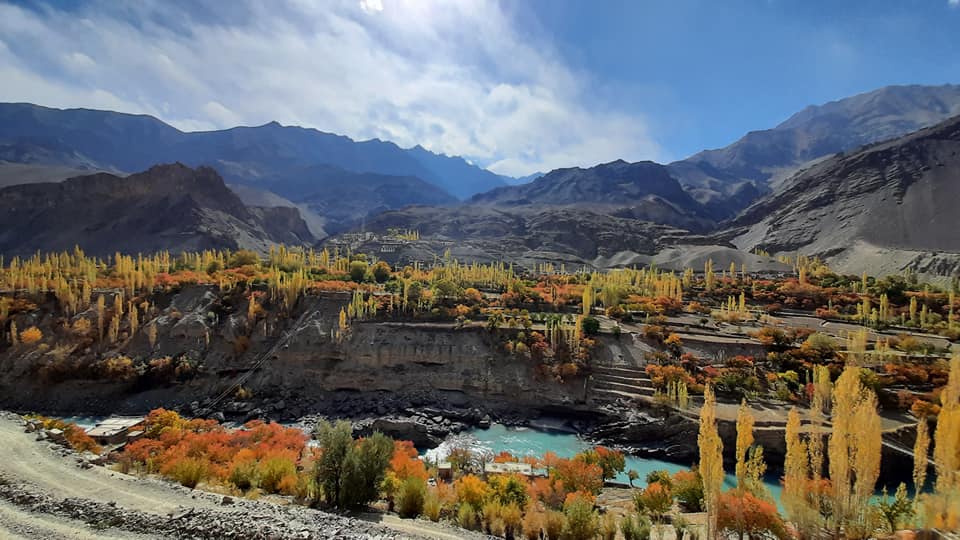
Where the River Remembers Older Stories By Declan P. O’Connor I. Opening: Along the Quiet Bend of the Lower Indus The corridor where silence carries culture There are stretches of the Himalaya that announce themselves with snow peaks and prayer flags, and there are others that must be listened to before they can be seen. The Lower Indus Brokpa Corridor belongs firmly to the second category. Driving west from Leh, the road holds to the river as if it were a rail, tracing a deepening gorge where the Indus has spent millennia cutting through rock and assumption alike. This is not a landscape that flatters the visitor with instant drama. Instead, the first things you notice are small: an irrigation channel disappearing into stone, a line of willow trees clinging to a ledge above the torrent, a cluster of whitewashed houses gathered around a barley field the size of a pocket handkerchief. For European travelers used to the Alps or the Dolomites, the Lower Indus Brokpa Corridor is disorienting in a gentler way. It is high, but not expressionistic; beautiful, but rarely symmetrical. The mountains rise like walls rather than peaks, and the life of the valley hugs the river in thin, green scripts. Each village – Takmachik, Domkhar, Skurbuchan, Achinathang, Darchik, Garkone, Biamah, Dha, Hanu, Batalik – seems to have been negotiated from the rock rather than granted by it. To move along this corridor is to move through a sequence of quiet compromises between water, gravity and human patience, stitched together by a road that sometimes feels provisional, as if it might at any point decide to slide back toward the river that allowed it to exist. How the Brokpa identity lives in fields, orchards, and faces The villages of the Lower Indus Brokpa Corridor are best known, in the fragmented vocabulary of travel writing, for the people who inhabit them. The Brokpa have appeared in coffee-table books and anthropological studies, shorthand for a community that has preserved particular dress, language and ritual forms along this river. Yet to arrive here expecting only ethnographic spectacle is to miss the deeper story. Brokpa identity is not confined to costume or festival; it is inscribed into terraced fields, apricot orchards, stone walls and the rhythm of irrigation days. You see it in the way water is shared, in how paths curve around sacred trees, in the patient labour that keeps barley, buckwheat and vegetables rooted in such improbable soil. In the lanes of Darchik or Garkone, faces and flowers do indeed catch the foreign eye, but they belong to a wider choreography that includes goats on narrow ledges, children chasing each other along the irrigation channels, women returning from the fields with sickles tucked under their arms. The Lower Indus Brokpa Corridor is not a museum of a “vanishing tribe”; it is a living, sometimes weary, often resilient rural world navigating change. Solar panels glint beside prayer flags; school uniforms brush past traditional headgear. The continuity lies less in an unbroken past than in a stubborn insistence on farming these slopes, season after season, even as the outside world keeps expanding the menu of imagined alternatives. II. Takmachik — The Threshold Village Where sustainable farming becomes a worldview Takmachik is often described as a model of sustainable tourism, but before it was a case study it was simply a village trying to survive on a narrow fold of arable land between cliff and river. Arriving there, you notice first the ordinariness of the place: children on their way to school, a shop selling biscuits and mobile top-ups, a prayer wheel waiting to be turned by hands on their way to somewhere else. Only slowly do you realise how carefully the community has tried to shape its relationship with visitors. Homestays are not an afterthought; they are an extension of household life, where apricot kernels are cracked in the courtyard while conversations about weather, migration and education unfold over butter tea and bread baked the same morning. In Takmachik, the language of “eco” and “sustainable” has not arrived as a marketing slogan pasted onto a generic trekking route. It emerges from a simple calculation: the fields, orchards and pastures that feed the village cannot be scaled up infinitely, but curiosity from outside can. The people of the Lower Indus Brokpa Corridor know better than most what happens when an ecosystem is pushed to the edge. So Takmachik has become a threshold of another kind – a place where European travelers can experiment with a slower, more attentive form of presence, and where the village can test, gingerly, how much of its privacy it is willing to place on the table alongside the apricot jam and homegrown vegetables. A place where the Indus introduces the traveler gently Every corridor needs a doorway, and Takmachik plays that role with a kind of understated grace. For those coming from Leh, the village offers the first opportunity to step off the road and onto paths that know nothing of asphalt or itinerary. The Indus flows below, sometimes visible, sometimes obscured by rock, and the sound of the river becomes a background presence, like a conversation happening in the next room. Paths wind between houses, spill into fields, and rise toward hillside shrines that look back over the valley with a wary, custodial gaze. The altitude is high enough to thin the air but low enough to allow barley and vegetables to grow, and that balance makes Takmachik feel unexpectedly hospitable, especially for those just beginning to adapt to the elevation of Ladakh. For European visitors attuned to dramatic introductions – airport runways framed by snow peaks, postcard monasteries perched on obvious ridges – the Lower Indus Brokpa Corridor makes a different proposition. In Takmachik, there is no singular “sight” that absorbs all attention. Instead, the village itself becomes the object of observation: how many walls must be repaired before sowing, how long the line of women at the communal water point, which field receives irrigation first after a dry spell. To walk here is to be introduced not to a monument, but to a pattern of life that will echo, with variations, all the way to Batalik. The corridor begins, quietly, with a village that has decided it would rather be known for its farming than for the number of rooms it can offer strangers. III. Domkhar — Stone, Light, and Human Scale Villages that cling to cliffs and memory West of Takmachik, the road keeps following the Indus as if reluctant to admit there might be any other logic to movement in such a narrow world. When you reach Domkhar, the mountains seem to close in, shouldering the river into a more tightly defined channel. The houses of the village appear to cling directly to the rock, stacked in a vertical grammar that makes sense only when you begin to walk the lanes yourself. It is easy, from the car window, to mistake Domkhar for a set of stone terraces pinned to a cliff; on foot, you discover that it is a three-dimensional debate with gravity, hospitality and memory, conducted in alleys barely wide enough for a laden donkey. The Lower Indus Brokpa Corridor is full of such negotiations, but in Domkhar they are especially visible. Stone is everywhere – in the retaining walls, the steps, the tiny courtyards, the prayer walls and the rough boundary markers that tell you when a path becomes a field. It is tempting to romanticise this immediacy, to turn it into evidence of rootedness and permanence. Yet talk long enough with an elder leaning against one of these walls and you will hear different tone: stories of years when the river froze late, when the barley failed, when sons left for the army or for city jobs that would never bring them back. Domkhar clings, yes, but it clings not only to the cliff; it also clings to an idea that life in this village is still worth the effort that its geography demands. The intimacy of barley fields beneath impossible rock formations Perhaps the most surprising element of Domkhar is not its stone but its softness. Just beyond the tight cluster of houses, barley fields spread out like small carpets laid carefully wherever the land relaxes enough to allow a little soil to settle. Above them, rock formations rear up in improbable shapes, eroded into towers, fins and ledges that look as if they might detach themselves and walk away when no one is looking. This juxtaposition – intimate fields under theatrical geology – is part of what defines the visual character of the Lower Indus Brokpa Corridor. It is a landscape where cultivation is always dwarfed but never entirely overshadowed, and where beauty depends on the stubborn insistence of green against stone. Walk along the irrigation channels in the late afternoon, when the sun slides behind the upper ridge and the valley fills with a soft, almost metallic light, and you begin to feel the proportions of Domkhar in your own body. Distances that looked negligible on the roadside become meaningful when climbed on foot; a short detour to a shrine turns into twenty minutes of steady breathing. For visitors from Europe, where the countryside is often understood through the convenience of car parks and waymarked trails, there is something quietly humbling about this intimacy. The fields are not scenic foregrounds to the mountains; they are the whole point. The rock formations may command the camera, but it is the barley that commands the calendar. IV. Skurbuchan — The Middle Kingdom of the Corridor A village large enough to gather stories Skurbuchan sits roughly in the middle of the Lower Indus Brokpa Corridor, and it has the feeling of a place where stories pause to collect themselves. Larger than Takmachik or Domkhar, with more visible infrastructure and a wider spread of houses, it serves as a local centre for schools, small shops and administrative routines that rarely find their way into travel writing
source https://lifeontheplanetladakh.com/blog/lower-indus-brokpa-corridor-ladakh-villages/


Comments
Post a Comment